Having just completed the cross-country Southern Tier Bike Route, I am not quite ready to return back to real life and the responsibilities that come with it. Pushing back my return to work date and delaying the house hunt, I decided why not whet my whistle for backpacking? While I love the adventure of bike touring and the stories and experiences that come from living off a bicycle, there is nothing quite like exploring the back-country with nothing to rely on but you and the gear you have on your back. The Tahoe Rim Trail (TRT) has always caught my eye as an epic thru-hike with great views in the Sierra. Only 165 miles with multiple bail out options, I set my sights on it and have been planning out this journey since even before the STBR.

The Tahoe Rim Trail, a relatively new thru-hike, circumnavigates Lake Tahoe on a relatively easy grade trail that offers epic views of the Tahoe basin. Before my 2018 JMT adventure, I spent a short time in Tahoe City and fell absolutely in love with Lake Tahoe and the depths of this blue jewel. So imagine my absolute joy when I saw that there was a thru-hike around it! And you don’t need permits!! With an explosion in interest of hiking and backpacking within the last 10 years and itchiness to get out thanks to COVID, a lot of trails and National Parks are requiring either a permit to hike or a reservation to enter. One thing about me is I hate the permit system and competing for a reservation to enter a National Park? Forget it. As of right now, the TRT does not require either of these, save for an overnight permit to enter Desolation Wilderness, but I’ll get to that later.

And another selling point of this trail? It’s completely dog friendly. Considering I was just away from Addie for 2 months and always miss her terribly when I go on trips, I wanted to take her with me to share in the adventure. She has done multiple multi-night hikes with me before that I have not documented in this blog and she handled them as if she was a packmule. She has her own backpack and carried her daily food and water. Even a 10 lb pack doesn’t slow her down! During one of our hikes she handled 18 mile days, swarms of angry hornets (she got stung at least a dozen times), and a near encounter with a rattle snake. None of this fazed her and she trekked on unbothered. She was even called the best trail dog an experienced hiker had ever encountered! I may be biased, but I agree wholeheartedly with his assessment.

Planning
A 165 mile thru-hike is not something to take lightly and thoughtful planning must be done to ensure a safe and successful hike. The resources I used to plan were the 4th edition of the Tahoe Rim Trail Guide by Tim Hausermann, Guthook for water and campsite information, various blogs, and the most useful of all – the Tahoe Rim Trail Association website. I have never come across a more concise and informative website for hiking ever. It has up to date trail/water conditions, resupply options, and all the information you would need to plan a thru-hike. I honestly could have gotten away with planning just by using this website. Needless to say, I’ll be donating to them as a thank you!
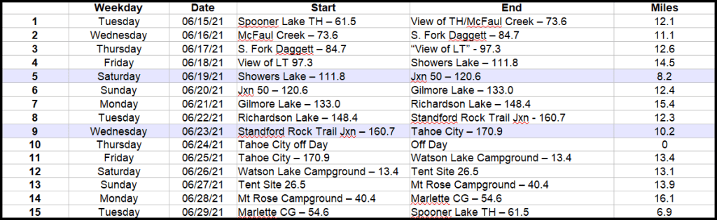
First thing’s first: Where to start? What way to go!? How long with this take!?! Well the answer to all three of these questions depend almost entirely on where to resupply. Most people complete this trail in 10-12 days. But given Addie has never gone so long on a trail, I don’t mind taking it slowly to ensure her health. So regardless, that means carrying multiple days worth of not only my food, but her’s as well. Not wanting to carry a 50 lb pack, I knew I wanted to do 2 resupply stops. A lot of folks will start at the popular Tahoe City trail head. It’s awesome that a major city is literally just feet from the trail, but the proximity to the trail seemed more appropriate for a resupply, not an entry/exit point. So it was established. Tahoe City will be a resupply stop! Another city not too far off the trail is South Lake Tahoe, which is almost exactly on the opposite side of the lake. It’s a perfect way to break up the hike, but given that it’s about 12 miles from the trail, we will either hitch or order an uber if cell service is in our favor.

So, with two resupply options solidified, the first question can be answered. Where to start? Well someplace between Lake Tahoe and South Lake Tahoe! The TRT is notorious for having a dry eastern section where there is very little reliable water sources. Unfortunately, Tahoe had a very low snow year so any water sources that aren’t rushing rivers should assumed to be dry. In order to ensure I have enough water for Addie and myself, I wanted to break up this eastern section. And it just so happens Spooner Lake outside of Carson City achieves this want perfectly. But it also causes a logistical problem. How do I get to the trailhead and where do I park my car? All sources did not recommend long term parking at less used trailheads because of human and bear break ins, so that option was out. I could park it at a hotel and pay a daily rate, but that can add up. I figured since I had just gotten done a cross country bike trip, why not ride that out and see if WarmShower hosts will be just as hospitable to a backpacker?! I sent out a message to the Wrights and asked if I could park my car at their home for the duration of my thru-hike. Not only were they very receptive towards that, but they even offered to let us stay and drive us to the trailhead the next morning!! WarmShowers never fails to amaze me. I even reached out to Blake in South Lake Tahoe to send my resupply package and spend a night off the trail. He responded that he was also thru-hiking the TRT! But found someone who was more than happy to help out. I’ll be running into him on the trail!! What are the chances!?
Now, what way to go? I didn’t put much thought into this question. From Spooner to South Lake Tahoe to Tahoe City to back to Spooner are all pretty equidistant, so direction doesn’t really matter. Most hikers go clockwise, so I decided to go with the flow of traffic to avoid encounters with other hikers (not because I’m snotty, but Addie can be).
So how long will this endeavor take? With all the time in the world, we can take it as slowly as needed. Not wanting to overtax Addie, I wanted to keep our days relatively short. I didn’t want to average more than 12 miles/day to keep her joints, paws, and mind all healthy. With special attention to water sources, I was able to achieve this mileage goal with 5 days between re-supplies and one rest day in Tahoe City. Of course, with any hike, itineraries are subject to change but I’m pretty happy with this schedule.
Oh dreaded permits. Yes, to thru-hike the TRT you do not need a permit other than a self registered one at the trailhead. But, if you’re spending a night in Desolation Wilderness (on the west side of the lake), you need an overnight permit – that you get from a lottery system. NO! But, luckily for us thru-hikers, we can bypass the lottery system and get a TRT Thru-hiker specific permit 2 weeks prior to entering Desolation Wilderness. The ranger who distributes these permits is quite possibly the most helpful woman I’ve ever spoken to and will go above and beyond to ensure that you have that permit no matter the situation.
As I mentioned earlier, California had a very low snow pack year. In years of high or even normal snowfall, a mid-June thru-hike would be a risky endeavor with a lot of the north facing slopes still holding onto feet of snow. Given that most of the snow has already melted, this year is a prime year to hike it early. Ideally, I wanted to hike the Four Passes Loop in CO as a shakedown hike, but Maroon Bells still has feet of snow. So it looks like we’re jumping headfirst into the TRT! We are starting June 15th and expecting to end June 29th, exactly 2 weeks on the trail. Plus the temperatures in June don’t rise too high. Days are in the 70s and nights drop into the 40s. Good thing I got Addie her very own sleeping bag!
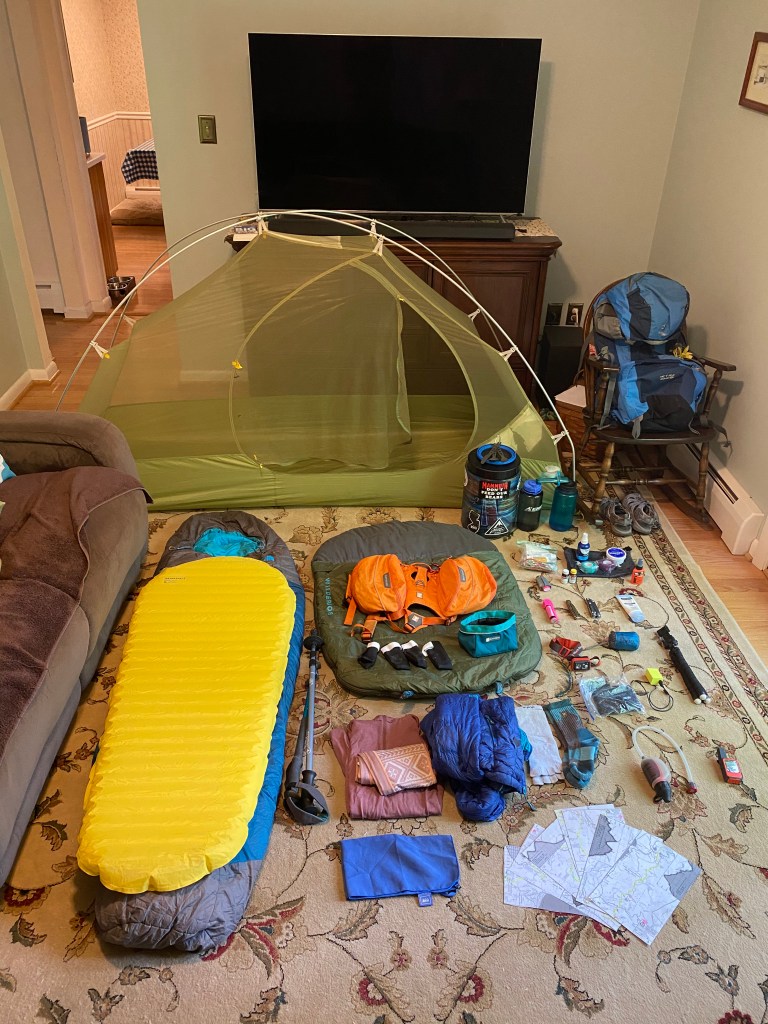
So permit is acquired, re-supplies are shipped out, and itinerary is set! Big Booty Judy is all geared up to go and Addie’s pack is awaiting another journey. Addie’s nails are clipped, the Subaru’s windshield is replaced and lubed up (wow that was a frustrating experience), and we are both very excited to get going! Well I mean Addie has no idea what’s in store for her, but if she did I’m sure her tail would sprain from nonstop excited wagging.
What if things go wrong?
The older I get, the more I realize I have inherited my mother’s tendency to over worry. Little fears snowball into ripped from sleep panics in the middle of the night. So I figured why not address these fears and have a plan should worse case scenario happen.
Addie: Having my precious Addie girl with me adds a layer of concern that otherwise I wouldn’t have alone or with another human. Though I’m sure she’s going to have a blast, she didn’t consent to this hike and she will be completely and wholly dependent on me to ensure her safety and health. This is no small matter. Should something happen to her on the trail, I would never forgive myself. I have a very large (and heavy) first aid kit full of dog specific ointments and salves for cuts, scrapes, and paw health. She has booties for the rocky sections and plenty of water to stay hydrated. If at any point she lags or demonstrates any sign that she’s not having fun, I have absolutely no problem carrying her pack or full out bailing out of the hike. I have a lot of pride when it comes to my own achievements, but will gladly swallow that pride to make sure Addie is happy, healthy, and safe.
Another great concern of mine with regards to Addie is her absolute fear of thunderstorms (she’s so neurotic she’s got a lot of fears. But you would too if someone gouged out your eye as a young pup!). Having spent the majority of days on the JMT seeking shelter from storms, I understand how terrifying thunder can be in the Sierras. But after asking locals, I was told that while thunderstorms can happen at any time, they are rare in the month of June. And when they do happen, you can see them from miles away. Fingers crossed they’re right, but should one pop up I’ll quickly set up my tent and just hold Addie until the storm passes. Or just knock her out with some benadryl, ha!
With a dog it’s probably going to increase the time it takes to hitch a ride into town. Or maybe people will take more pity on a one eyed dog with a pack and stop quicker to offer assistance? Who knows, that’s a toss of the die. Fortunately, for an additional cost, Uber allows dogs. So worse comes to worse, if we have service I’ll just order an Uber.
I’m not too concerned about Addie and bear/wildlife encounters. I will have her leashed and attached to me at all times. I have heard that coyotes will lure a dog back into their pack and kill. Not on my watch! And with her nasty dog smell and collar jingling and jangling, she’ll likely act as a bear deterrent.

Water: As I mentioned before, what used to be reliable water sources in the past can no longer be counted on this year during a low snow year and drought. I have been keeping an eye on Guthook for the most up to date reports on water flow from people who are actually on the trail right now. For those sections that have 15 mile stretches of no water, I will be caching water along the trail to refill along the way. To prevent people from using the jugs I’ll be caching, I’m going to bring a few more “free” jugs to discourage looting mine. I’ll have 3 places along the trail I’ll be caching, which should hopefully be plenty.
Me: Should injury or illness befall me, there are plenty of bailout points along the TRT we can utilize to get a ride into a town. If something catastrophic happens and we’re out of cell coverage, I’ll be bringing the Garmin InReach along. I just bought SAR insurance, so I’m not overly fearful of the bill that comes along with a helicopter rescue, but that won’t even be necessary. I’m much less concerned with my well being than Addie’s. I have also gotten into watching extreme rescue shows and podcasts because, well, they’re really interesting and demonstrates the will and ability of the human body to survive horrific events. Besides entertainment, it also serves as a lesson as to what to do and what not to do in an emergency survival situation – mainly being don’t panic and ALWAYS share your itinerary with a friend/family member. I’m hoping I won’t find myself in such a situation, but it’s better to be prepared!
Time to go!
We are setting out Wednesday 6/9 for California. Since I’m convinced Addie will drop dead from a heart attack flying, we’re road tripping out there! We have a very loose schedule for getting into Carson City 6/14, but are giving it plenty of time for rest breaks – and even giving Sheena a visit out in Colorado! So all that’s left to do is finish going over gear, pack up the Subaru, and go! Hopefully it’ll be a great and successful trip and Addie will come home with a great trail name 🙂
